|
A Bold and Beautiful Rockface Pildappa Rock
Pildappa Rock
Pildappa Rock is a unique pink inselberg
located 15 kilometres northeast of Minnipa. Situated in South Australia's
granite country, locals proudly proclaim Pildappa to rival the more
famous "Wave Rock" - a sandstone wave form located in Hyden Western
Australia.
Blue Skies and Pink Granite
Formed about 1500 million years ago Pildappa
Rock is part of the vast Gawler Craton - a geological shield structure
covering central Eyre Peninsula, the Gawler Ranges and large parts
of outback South Australia. Geologists refer to Pildappa Rock and
other inselbergs in the area as belonging to the Hiltaba suite of
rocks - basically orthoclase rich pink granites dating from Eyre Peninsula's
Precambrian age.
Nearby the Gawler Ranges were formed as
a result of volcanic action. Unlike the Gawler Ranges however, Eyre
Peninsula's inselbergs were formed as Batholiths or granite domes
some 7 kilometres below the earth's surface. Clearly much soil erosion
has occurred during the past 1500 million years. Equally remarkably,
Pildappa Rock and many other Australian inselbergs exhibit very slow
rates of weathering - with numerous studies indicating exposed granite
surfaces eroding at rates below 50 centimetres per million years.
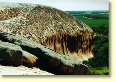
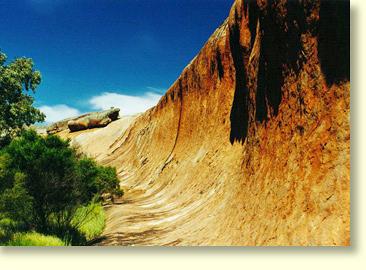
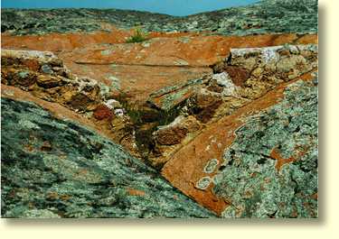
Pildappa's decaying granite sheets
As an inselberg Pildappa Rock's outstanding
feature is a unique wave form or "flare" structure extending for perhaps
100 metres. In terms of height the flared structure is perhaps 2 to
3 storeys tall. In common with other inselbergs, Pildappa's flared
slope is the product of complex chemical weathering below the surface.
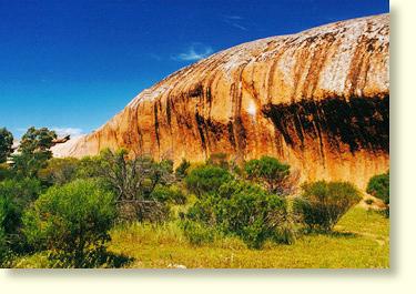
Pildappa Rock's Flare Structure
Geologists believe the process of flare
formation typically involves water runoff seeping into the soil at
the base of granite rock faces. Over time, water and permanently moist
soil conditions act together to chemically weather away highly reactive
granite minerals such as orthoclase and mica. All this can take place
at depths of up to 30 metres below the surface. In the case of Pildappa
Rock soil levels have also gradually eroded away thereby exposing
the prominent flare structure that we can see today.
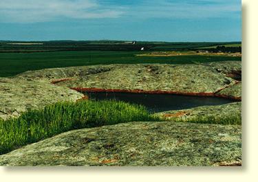
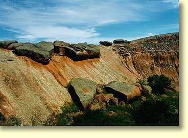
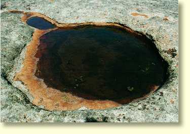
Gnammas Rockholes
Elsewhere on Pildappa Rock other typical
inselberg landforms can also be seen. Decaying granite sheet structures,
minor tafoni forms, and "water grooves" known as rillen can all be
found. A must see for vistors to Pildappa are the numerous gnamma
waterholes to be found at the top of the rock.
Can you spot the old dam wall?
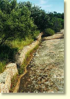
Water Gutters
at the base of Pildappa Rock |
Prior to European settlement gnamma rockholes
were the only permanent source of water to be found in this part of
Eyre Peninsula. For the local Kukatha tribe of aborigines such rockholes
were an essential survival resource in a characteristically dry and
arid environment. Early European
settlers also recognised the value of such waterholes. At Pildappa
pioneering farmers even constructed dam walls at the top of the rock
in order to increase the rainfall catchment area of gnamma rockholes.
Below Pildappa Rock visitors will also find an extensive system of
man made gutters. These gutters were constructed in 1928 and designed
to channel water runoff into a huge underground water tank on the
northern side of Pildappa Rock.
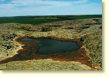
Gnamma Rockholes: a good habitat for tadpoles
For
travelers wishing to get off the beaten track Pildappa is definitely
an excellent and accessible bush picnic site. Please note that the
local council does not actually encourage camping at this site. At
the base of Pildappa Rock travelers will find 2 free gas barbecues,
rainwater tanks and ecologically friendly toilets. Nullarbor Net wishes
to thank Le Hunte Council and the Minnipa Progress Association for
making such facilities available to all travelers. If you haven't
guessed by now, Nullarbor Net definitely recommends you pay a visit
to Pildappa Rock - and don't forget to bring a roll of film!
Nullarbor Net
Tips: If you find Pildappa Rock to your liking try clicking
on the links below to view Murphys Haystacks and Ucontitchie Hill.
Abstract Patterns
Shallow Rock Pan Feature
|